http://www.washco.state.ut.us/
Washington County is located in the southwestern corner of Utah. The county was formed on March 3, 1852 by an act of the territorial legislature. Harmony, one of the only settlements in the area at that time, was appointed as the first county seat. The first boundaries of Washington County stretched nearly 600 miles - the entire width of the territory. As the territory was settled the county boundaries changed several times and the county seat was later changed to St. George.
Most of the early residents of the county were Mormon Pioneers and the area was agricultural. Today, Washington County is one of the fastest growing areas of the country, as declared in 2006. People are migrating here now to enjoy the mild winter climate, beautiful scenery, and comfortable lifestyle.
St. George is the largest city in Washington County. The County was named for the first President of the U.S., George Washington.
The county has a total area of 2,430 square miles and an elevation that varies from 2,178 to 10,194 feet. The 2008 estimated county population is around 143,000.
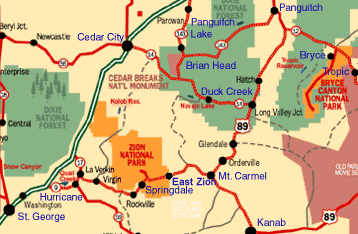
It has two National protected areas: Dixie National Forest and Zion National Park.
Most of the early residents of the county were Mormon Pioneers and the area was agricultural. Today, Washington County is one of the fastest growing areas of the country, as declared in 2006. People are migrating here now to enjoy the mild winter climate, beautiful scenery, and comfortable lifestyle.
St. George is the largest city in Washington County. The County was named for the first President of the U.S., George Washington.
The county has a total area of 2,430 square miles and an elevation that varies from 2,178 to 10,194 feet. The 2008 estimated county population is around 143,000.
It has two National protected areas: Dixie National Forest and Zion National Park.
The major highways are: Interstate 15, State Route 9, State Route 17, State Route 18, and State Route 59.
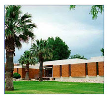
In addition to the primary and secondary schools that compose Washington County School District, the county is home to Dixie State College of Utah in St. George, with a campus extension in the neighboring town of Hurricane.
In addition to the primary and secondary schools that compose Washington County School District, the county is home to Dixie State College of Utah in St. George, with a campus extension in the neighboring town of Hurricane.