.
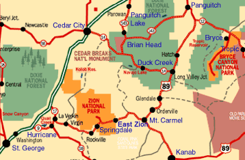
Because the St. George area is located between the Rocky Mountains and the desert southwest, it features the distinct landscapes of both. It has forested mountain ranges and high plateaus, along with rugged and starkly beautiful red rock desert.
.
.
Showing posts with label history. Show all posts

Monday, May 19, 2008

Volcanoes in St. George

Cinder cone volcanoes within Snow Canyon State Park, near St. George


Volcanoes are created by internal forces within the Earth that cause heated, melted rock (magma) to rise to the surface. First collecting in magma chambers, some of the magma eventually pushes upward through cracks (vents) to the Earth's surface. As the magma reaches the surface, it loses some of its gases and turns into lava. Volcanoes are created by the release and build-up of lava and other materials. Volcanoes have varied shapes and sizes, but are divided into three main kinds depending on the type of material that reaches the surface and the type of eruption that ensues. One such kind is cinder cone.

A cinder cone is a volcanic cone built almost entirely of loose volcanic fragments, ash, and pumice. Cinder cones are the simplest and smallest type of volcano, built from particles and blobs of congealed lava ejected from a single vent. As the gas-charged lava is blown violently into the air (often hundreds of feet), it breaks into small fragments that solidify and fall as cinders (about ½ inch in diameter) that pile up around the volcano’s vent to form a circular or oval cone shape. The molten rock solidifies instantly, often preserving bubbles created by escaping gasses. If an eruption of this type continues long enough, fragments accumulate layer by layer to form a cinder cone. Cinder cones can grow up to 2,300 feet high, but most are between 100 and 1,000 feet. Most cinder cones have a bowl-shaped crater at the summit and rarely rise more than a thousand feet or so above their surroundings.

Cinder cone volcanoes are found in many places in Utah, and the city of St. George is located in a volcanic field. North of St. George is Snow Canyon State Park and within it’s boundaries are two cinder cones that are close to the road. The Cinder Cone Trail is a 1.5 mile path that climbs one of the extinct volcanoes. Despite its short length, this path is difficult as people must climb up and down steep slopes with volcanic rock that makes it hard for one to keep their footing. However, the views at the top of the volcano are well worth the effort. Besides, how often can one climb a volcano?

Thursday, March 20, 2008

If you are into prehistoric stuff.....


click image to enlarge


......you might enjoy learning more about St. George’s Dinosaur tracks discovery site. Click on this first link below to read about the first discovery in the area in 2000, and also about the new museum.

http://www.sgcity.org/dinotrax/indexmain.php


Click on this second link below, a YouTube video, about the museum and some interesting facts and views inside the museum.

http://www.youtube.com/watch?v=LtNSTlI_xew

Monday, March 3, 2008

Green Gate Village Historic Inn (in St. George)

This Folkart of the Green Gate Village is by renowned artist Eric Dowdle

Green Gate Village Historic Inn, is one of Utah's "hidden treasures". Behind the green gates you'll discover 14 buildings with nine beautifully restored historic homes nestled in a garden-like setting around the "Village Green".


What is the history behind the name “Green Gate” Village? In 1877, Brigham Young ordered white paint for the new St. George Temple. When the shipment finally arrived by wagon he was disappointed to learn that the paint was green, not white. Unable to return it, he gave the green paint to local St. George residents to gild their gates and fences. Only one of those green gates still remain from a 130 years ago and is on display in the formal garden of the Green Gate Village. The other gates surrounding the Village are patterned after this treasured original.

To see photos of the homes and learn more about the "Village" ....click on the following link:

Tuesday, December 4, 2007

Utah's World Famous Bonneville Salt Flats


The Bonneville Salt Flats is located near the Utah-Nevada border, along I-80. It is one of the many unique natural features in Utah. It covers an area of more than 30,000 acres and it is administered by the Bureau of Land Management.

During the last Ice Age, about 15,000 years ago, Lake Bonneville was about the size of Lake Michigan. It covered one-third of present day Utah and parts of surrounding states. You can see traces of the shorelines, representing different levels of the receding lake, etched into the mountains surrounding the salt flats.

The Bonneville Salt Flats and the Great Salt Lake are what remains of ancient Lake Bonneville. Wind and water each combine to create the flat surface of salt. Every winter, a shallow layer of standing water floods the surface of the salt flats. Then during spring and summer, the water slowly evaporates while winds smooth the surface into a vast, nearly perfect flat plain.

The salt surface contains potassium, magnesium lithium and sodium chloride (which is common table salt).

Around 1824, Jim Bridger and other mountain men explored the Great Salt Lake desert region. The first recorded crossing of the desert was made in 1845 by Captain John C. Fremont's survey party, with scouts Kit Carson and Joe Walker. Early the next year, 23 year old Lansford Hastings retraced Fremont's trail across the salt plain. Joe Walker's writings warned emigrants not to attempt the untried route; however, Hastings convinced several emigrant parties to follow him.

Despite Walker's warnings, the Donner-Reed party, seeking a shortcut to California in 1846, attempted the "Hastings Cutoff". They failed to take enough water and lost a critical number of oxen. Four of their wagons were abandoned just 10 miles northeast of the salt flats. Time was lost, and the delay resulted in their late arrival to the Sierra Nevada Mountains and their tragic winter.

Later, in 1910, the first permanent crossing of the Bonneville Salt Flats was completed when the Southern Pacific Railroad was built linking Salt Lake City and San Francisco.

The Bonneville Salt Flats is named in honor of Captain B.L.E. Bonneville, whose expeditions in the 1830's proved the area was part of an ancient basin.

Try to imagine a place so flat you seem to see the curvature of the planet, so barren not even the simplest life forms can exist. Imagine the passing thunder of strange vehicles hurtling by on a vast dazzling white plain. This is not an alien world far from earth; it is Utah's famous Bonneville Salt Flats.

Thousands of visitors, commercial filmmakers, and of course, high speed auto racers, make the Bonneville Salt Flats a world famous destination.
By way of information….one scene in the third film of the “Pirates of the Caribbean” series was filmed on the Salt Flats (the scene was when the pirate ship Pearl was on this great white unending plain).

The salt flats' potential for racing was first recognized in 1896 by W.D. Rishel who was scouting a bicycle race course from New York to San Francisco. Rishel returned and convinced daredevil Teddy Tezlaff to attempt an automobile speed record on the flats. Tezlaff drove a Blitzen Benz 141.73 m.p.h. to set an unofficial record in 1914.

The salt flats drew international attention in the 1930's when Utah driver Ab Jenkins lured British racer Sir Malcolm Campbell to compete for speed records on the salt surface.

By 1949, the raceway on the Bonneville Salt Flats was the standard course for world land speed records. On this natural straightaway the 300, 400, 500, and 600 mile per hour land speed barriers were broken.

Since the first speed record attempts in 1914, hundreds of records have been set and broken in a variety of automotive and motorcycle classes.

Typically, speed trials are scheduled throughout the summer and fall at the Bonneville Raceway. Most events are open to the public. The annual Speed Week is usually held in mid-August.

Friday, November 16, 2007

Utah's Dinosaur Land


Yes, dinosaurs really did exist! And Utah can prove it.

Millions of years ago, all types of dinosaurs roamed across the landscape of what is now Utah. Literally thousands of actual remnants of this fantastic prehistoric era are carefully preserved and interpreted in sites, state parks, museums and quarries all across the state of Utah...just awaiting your discovery.
There are prehistoric sites and attractions throughout all of Utah....the northern part, northeastern part, central part, eastern part, southeastern part, and the southwestern part.
By visiting these dinosaur sites, you can see and learn how these fossilized remains have been protected and preserved. These prehistoric fossils and bones represent a priceless part of Utah's past, and these remnants are protected by federal regulations.


Interesting Facts....


**Digging up new types of dinosaurs allows paleontologists at Dinosaur National Monument in Jensen, Utah, to reconstruct the environment that the dinosaurs lived in. Each piece of information, from the types of rocks, to plant fossils, to remains of the frogs, lizards, and salamanders living at the same time as the dinosaurs, helps scientists describe what northeastern Utah looked like when the dinosaurs roamed.

**Fossils are remains or traces of ancient life. They provide the clues that paleontologists use to learn about prehistoric animals and plants. When a plant or animal dies, it usually decays or is eaten by other animals. However if it is buried before that happens, it may become a fossil. Hard materials, such as wood, bones, shells, and teeth have a better chance of being buried and fossilized because they decay more slowly than soft tissues like leaves or skin.

**The dinosaurs of Douglass Quarry, in Jensen, Utah, lived in the middle of the Age of Dinosaurs. They were one of nature's experiments that succeeded. The first dinosaurs survived, thrived, and ruled the earth for some 150 million years, while adapting to changing conditions. The early dinosaurs multiplied. Some grew larger, some began to walk on four legs, and others grew into different shapes. Each new feature.. a long neck or sharp teeth, or bony plates, if it helped the animal survive, was passed on to later generations. These features became the hallmark of each new kind of dinosaur.

**In order to be classified as a dinosaur, an animal must have...

1... hip, knee, and ankle bones that allow it to stand with its legs directly under its body.
2... a ridge on the upper arm bones.
3... jaw muscles that attach to the top of the skull.
4... three bones (that make up one side of the hips) that form an open socket for the thigh bone to fit in.
5... the second finger is the longest digit of the hand.


Dinosaurs in Southwestern Utah....

The St. George, Utah Dinosaur Discovery Site at Johnson Farm.. http://www.dinosite.org/ Dinosaur tracks were discovered on the farm in February, 2000, and it has become quite an attraction. The site is in the early stages of scientific study - so far more than 1,000 tracks have been found within a 10-acre area. Most were made by Dilophosaurus-like creatures and are three-toes, 13-18 inches long. There are also some smaller tracks and researchers have identified skin prints and impressions made by tail drags and swimming movements.
The tracks were found in large slabs of sandstone from the Moenave Formation, dating back some 205 million years to the beginning of the dinosaur era. Residents tromped over that very sandstone for years, never realizing it sheltered such treasures. Nobody new, until Dr. Sheldon Johnson flipped over a slab while trying to level his land. There, on the underside, the tracks were clearly visible.
Most of the tracks are actually "negative impression" casts that appear as bumps on the stone. The area was the bottom of an ancient freshwater lake in the center of the super-continent Pangea. Footprints left in the mud filled with silt and sand, and more sand was deposited over the top. The mixture eventually solidified into sandstone and mudstone, forming the casts. Now, when the slabs are flipped over, the casts appear, much like Jell-o popping out of a mold.
Dr. Johnson donated his land to the city of St. George and the U.S. Congress appropriated funds to help construct a science and visitor center. Volunteers do most of the work at the site.


~ ~ ~ Readers please note: This article is part of a much larger article I wrote in the Story Pages section of Footnote.com.http://www.footnote.com/page/1586/utahs_dinosaur_land/ I used about 50 photos and I also write under a different name. I have about 25 stories that I have written on the Footnote website, so far.